About Us
What Is Assist America?
Clients
Press Room
Privacy Policy
For Group Benefits
Overview
Advantages
Member Services
Case Studies
Testimonials
Mobile App
For Students
Overview
Advantages
Student Services
Case Studies
Mobile App
Useful Links
How/When to Contact Us
Additional Services
Identity Protection
Overview
Login
Videos
ClaimAssist
SecurAssist
PetAssist
Contact Us
Princeton
Hyderabad
Manila
Beijing
Beirut
Member Login
|
Client Login
Pre-Trip Information
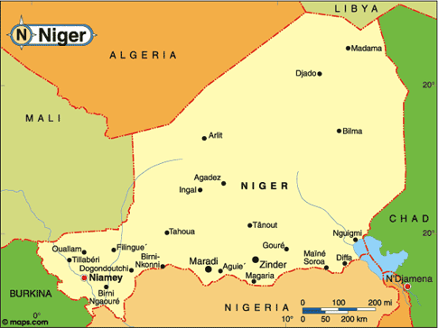
Country Profile: Niger
Select A Country
----------
Afghanistan
Albania
Algeria
Andorra
Angola
Antigua
Argentina
Armenia
Australia
Austria
Azerbaijan
Bahamas
Bahrain
Bangladesh
Barbados
Belarus
Belgium
Belize
Benin
Bhutan
Bolivia
Bosnia-Herzegovina
Botswana
Brazil
Brunei
Bulgaria
Burkina Faso
Burma (Myanmar)
Burundi
Cambodia
Cameroon
Canada
Cape Verde
Central African Republic
Chad
Chile
China
Colombia
Comoros
Congo (DRC)
Congo (RC)
Costa Rica
Cote d `Ivoire
Croatia
Cuba
Cyprus
Czech Republic
Denmark
Djibouti
Dominica
Dominican Republic
East Timor
Ecuador
Egypt
El Salvador
Equatorial Guinea
Eritrea
Estonia
Eswatini
Ethiopia
Fiji
Finland
France
Gabon
Gambia
Georgia
Germany
Ghana
Greece
Grenada
Guatemala
Guinea
Guinea-Bissau
Guyana
Haiti
Holy See
Honduras
Hungary
Iceland
India
Indonesia
Iran
Iraq
Ireland
Israel
Italy
Jamaica
Japan
Jordan
Kazakhstan
Kenya
Kiribati
Korea, North
Korea, South
Kuwait
Kyrgyzstan
Laos
Latvia
Lebanon
Lesotho
Liberia
Libya
Liechtenstein
Lithuania
Luxembourg
Madagascar
Malawi
Malaysia
Maldives
Mali
Malta
Marshall Islands
Mauritania
Mauritius
Mexico
Micronesia
Moldova
Monaco
Mongolia
Morocco
Mozambique
Namibia
Nauru
Nepal
Netherlands
New Zealand
Nicaragua
Niger
Nigeria
Norway
Oman
Pakistan
Palau
Panama
Papua New Guinea
Paraguay
Peru
Philippines
Poland
Portugal
Qatar
Republic of North Macedonia
Romania
Russia
Rwanda
Saint Kitts & Nevis
Saint Lucia
Saint Vincent & Grenadines
Samoa
San Marino
Sao Tome & Principe
Saudi Arabia
Senegal
Serbia
Seychelles
Sierra Leone
Singapore
Slovakia
Slovenia
Solomon Islands
Somalia
South Africa
Spain
Sri Lanka
Sudan
Suriname
Sweden
Switzerland
Syria
Tajikistan
Tanzania
Thailand
Togo
Tonga
Trinidad & Tobago
Tunisia
Türkiye
Turkmenistan
Tuvalu
Uganda
Ukraine
United Arab Emirates
United Kingdom
United States
Uruguay
Uzbekistan
Vanuatu
Venezuela
Vietnam
Yemen
Zambia
Zimbabwe
View Regions
Current Date:
Current Time:
Region:
Africa
Capital:
Niamey
Population:
22,749,426
Area Total:
1,267,000
Area Land:
1,266,700
Climate:
Desert; mostly hot, dry, dusty; tropical in exteme south
Country Overview
People
|
Cultural Etiquette
|
Travel Guide
|
Health Advisory
Country Overview
Largest Cities
City
Population
Estimated
Maradey
163,487
2020
Niamey
774,235
2020
Zinder
191,424
2020
Other Key Data
Region:
Africa
Population:
22,749,426
Area Total:
1,267,000km
2
Area Land:
1,266,700km
2
Coast Line:
0km
Capital:
Niamey
Climate:
Desert; mostly hot, dry, dusty; tropical in exteme south
Languages:
French (official)
Hausa
Djerma
Currency:
1 CFAF$ = 100 centimes
Holiday:
Republic Day is 18 December (1958), Independence Day is 3 August
Average Daily Temperature
January:
°C / 71.80°F
July:
°C / 85.20°F
Annual Rainfall:
mm / 23"
Boundaries
Nigeria
1,497 km
Chad
1,175 km
Algeria
956 km
Mali
821 km
Burkina Faso
628 km
Libya
354 km
Benin
266 km
Ethnic Divisions
Hausa
56.00%
Djerma
22.00%
Tuareg
8.00%
Fula
8.00%
Beri Beri (Kanouri)
4.00%
Arab, Toubou, and Gourmantche
1.00%
French expatriates
1.00%
Religions
Muslim
80.00%
Indigenous beliefs and Christians
20.00%
CountryWire
From youth bulges to graying societies: The demographic dynamics that are upending the world
4/6/2026 12:00:00 AM
Trump’s framing of Nigeria insurgency as a war on Christians risks undermining interfaith peacebuilding
1/28/2026 12:00:00 AM
Benin’s failed coup: three factors behind the takeover attempt
12/9/2025 12:00:00 AM
Guinea-Bissau’s military takeover highlights the nation’s sorry history of coups and a deepening crisis across the region
12/1/2025 12:00:00 AM
What is Françafrique? The taboo word that reveals the shifting influence of France in Africa
11/19/2025 12:00:00 AM

 Current Date:
Current Time:
Region:
Africa
Capital:
Niamey
Population:
22,749,426
Area Total:
1,267,000
Area Land:
1,266,700
Climate:
Desert; mostly hot, dry, dusty; tropical in exteme south
Current Date:
Current Time:
Region:
Africa
Capital:
Niamey
Population:
22,749,426
Area Total:
1,267,000
Area Land:
1,266,700
Climate:
Desert; mostly hot, dry, dusty; tropical in exteme south